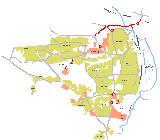
Mosborough Townships
In the 1970's the City Council developed a concept of a new town to the South East Corner of Sheffield, an area previously part of Derbyshire, the new town was called Mosborough Townships. Each township was approximately 1km square, featured a local centre, with shops, a pub, a school and community facilities. Each township also planned the mixed development of both local authority and privately owned housing.
The plan developed into real houses, roads and communities, however, in the late 1970's the nation was in turmoil, the country was crippled by national strikes and public spending dried up. The dream that was Mosborough Townships, began to look very unsustainable
Circa 1972 Network ::
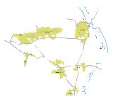 The historical road network at this time was based upon the old A616
Sheffield to Newark Trunk Road going NW-SE, the B6053 Rotherham to
Staveley, a less important B6058 link between Mosborough Village and
Killamarsh and a minor link between Gleadless and Beighton, through
Hackenthorpe Village.
The historical road network at this time was based upon the old A616
Sheffield to Newark Trunk Road going NW-SE, the B6053 Rotherham to
Staveley, a less important B6058 link between Mosborough Village and
Killamarsh and a minor link between Gleadless and Beighton, through
Hackenthorpe Village.
Much of the district was farmland, the border between West Riding of Yorkshire and Derbyshire was just to the south of Hackenthorpe. This was to change soon, with both Mosborough and Halfway being brought into the new Metropolitan County of South Yorkshire.
Circa 1978 Network ::
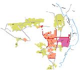 From the early 1970's the City Council laid down the beginnings of
the new local road network. Initially, three new north-south routes
where built, Moss Way, Eckington Way and Rother Valley Way, these
were connected east-west with another new route, Owlthorpe Greenway.
The existing road network was used to link the routes both in the
north with Beighton Road and in the south with B6058 Station Road.
An additional east-west route was built between the A616 and the
B6053 Rotherham Road, this was called Windmill Greenway.
From the early 1970's the City Council laid down the beginnings of
the new local road network. Initially, three new north-south routes
where built, Moss Way, Eckington Way and Rother Valley Way, these
were connected east-west with another new route, Owlthorpe Greenway.
The existing road network was used to link the routes both in the
north with Beighton Road and in the south with B6058 Station Road.
An additional east-west route was built between the A616 and the
B6053 Rotherham Road, this was called Windmill Greenway.
The new road network formed the initial three housing Townships of Halfway, Shortbrook and Waterthorpe and a fouth primarily industrial zone called Holbrook. The name Shortbrook was short lived, becoming known as Westfield on most publications and maps in the early 1980's. One key feature of the new network was the grid network of Distributor Roads and a secondary network of Internal Distributors, which curved out the internal access routes and defined where the bus routes were to go.
Noticeable differences of the 1978 network compared to today are;
:: Moss Way - Northern link into Beighton Road was initially a three
arm roundabout, with Beighton Road being the through route. Today
the roundabout has long gone, replaced by a tee junction with
Beighton Road now the minor arm and Moss Way the through route,
running north-south. Beighton Road to the east is now a service road
providing parking for a new Police Station.
:: Eckington Way - Northern link into Beighton Road, was initially a
tee junction, with Beighton Road being the through route.
:: Eckington Way - Junction with Owlthorpe Greenway, was initially a
very small roundabout, this was replaced around 1995 with a signal
controlled crossroads as part of the SYLRT project.
:: Eckington Way - Junction with Station Road, the roundabout shown
in the circa 1978 plan replaced a signal controlled crossroads,
however, the development of a new supermarket just to the south of
this junction in around 1997 replaced the older small roundabout
with once approximately twice the size.
The new network was known under design and construction by a numbered network system, if anyone can supply details of the network numbering system I would be very grateful if you could e-mail me !
Circa 1984 Network ::
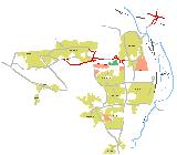 By the early 1980's, construction had slowed, the country was still
recovering from the 3 day week, the steel workers had been in a long
drawn out dispute and the miners had yet to feel the agony of a 12
month dispute. Sheffield was almost bankrupt and building of council
housing had been stopped by government decree. However, not
everything came to a halt in the building of Mosborough, the private
investors continued to trickle investment into the area, with a few
privately owned housing estates, more new industry in the Holbrook
Industrial Zone and brightest of all, the District Centre that had
been at the heart of the Townships development for almost 15 years,
began to look as thought it would be built.
By the early 1980's, construction had slowed, the country was still
recovering from the 3 day week, the steel workers had been in a long
drawn out dispute and the miners had yet to feel the agony of a 12
month dispute. Sheffield was almost bankrupt and building of council
housing had been stopped by government decree. However, not
everything came to a halt in the building of Mosborough, the private
investors continued to trickle investment into the area, with a few
privately owned housing estates, more new industry in the Holbrook
Industrial Zone and brightest of all, the District Centre that had
been at the heart of the Townships development for almost 15 years,
began to look as thought it would be built.
The most notable development to the road network in the early 1980's was the upgrade of the northern most east-west link, this involved the construction of a bypass to the south of Hackenthorpe and extending both Moss Way and Eckington Way further north. The Moss Way extension was significant in public transport terms as it would later, under bus deregulation serve as the major bus link from the townships into the city centre.
The naming of the Hackenthorpe bypass was notable as it was named after a City in the former Soviet Union, which had a long history of steel production, hence Donetsk Way was born. The newly constructed Aston Bypass can be seen to the north-east, linking the M1 at Aston (J31) to the old A57 at Fence, bypassing hundreds of homes in Aston, Swallownest and Aughton. In doing so opening up acres of development land that would see the population of the three villages double.
In terms of housing, a number of small infill sites in both Waterthorpe and Halfway filled the empty plots, but perhaps more significantly, the building of housing to the south of Beighton got underway, this area became known as Sothall, acquiring the name from a smaller hamlet in the south of Beighton
Circa 1990 Network ::
 By the 1990's all building of Local Authority housing had long
finished, the private sector was starting to boom on the back of the
new district centre, now called Crystal Peaks, that opened in 1986,
the World Student Games had brought the city back to the world
stage, sadly, now for sport rather than steel production.
By the 1990's all building of Local Authority housing had long
finished, the private sector was starting to boom on the back of the
new district centre, now called Crystal Peaks, that opened in 1986,
the World Student Games had brought the city back to the world
stage, sadly, now for sport rather than steel production.
In terms of roads though, the focus on major roads was to the north of the area, with the completion of the Mosborough Parkway in 1986 along with links to both Moss Way and Eckington Way. Ironically, the Mosborough Parkway laid quiet for some time, often referred to as the road to no-where due to the missing links at each end. The plan was to extend the route to the west and join the Sheffield Parkway and to the east to join the Aston Bypass. This first stage of the Mosborough Parkway put an end to the dream of the Expressway that had been planned for so long, which would have provided a dual carriageway and parallel collector/distributor links.
The majority of housing at this time was for private sale, with the Sothall area extending south and a large development to the south of Hackenthorpe, which would later become known as Owlthorpe. Minor development sprung up adjacent to Mosborough Moor and also Eckington Way. Notably, the first new housing for rent in the area was built in 1988, in Waterthorpe, this was an early seed of what was to replace Local Authority housing.
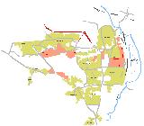
Circa 2000 Network ::
 By the new Millennia, Sheffield was going through almost a
reinvention of itself. In the last 10 years, the city had seen the
opening of the £250M Meadowhall Shopping Centre, numerous retail
parks, including one in Mosborough called Drakehouse, new office and
city living developments littered the city and the city was well and
truly recovering from the nightmare years of the declining Steel and
Coal Industries, the Miners Strike and the "Socialist Republic of
South Yorkshire".
By the new Millennia, Sheffield was going through almost a
reinvention of itself. In the last 10 years, the city had seen the
opening of the £250M Meadowhall Shopping Centre, numerous retail
parks, including one in Mosborough called Drakehouse, new office and
city living developments littered the city and the city was well and
truly recovering from the nightmare years of the declining Steel and
Coal Industries, the Miners Strike and the "Socialist Republic of
South Yorkshire".
In Mosborough, numerous private developers had built on the many remaining smaller sites, the larger developments saw the creation of Oxclose, with housing, industry and a supermarket. There were also large developments in Owlthorpe and to the west of Beighton.
South Yorkshire Light Rapid Transit (SYLRT) brought Sheffield the long planned £230M "Supertram", however, construction was a major headache, for the Supertram team, traders where hit by roadworks, residents complained and the bus operators felt the competition would damage their business. The route reached as far as Mosborough, travelling along Sheffield Road, Donetsk Way, past Crystal Peaks, onto Eckington Way to Halfway. The tram system was initially in independent development, but after initial patronage problems fell into financial crisis, which resulting in Stagecoach buying the venture.
The most significant roads development was the completion of the Mosborough Parkway to the north of Beighton, which created dual carriageway through a massive rock cutting between Eckington Way and Beighton Road, then reducing to single carriageway across a long high level viaduct to meet the Aston Bypass in Rotherham. Other notable developments were the completion of the Drakehouse internal network and the introduction of two new roundabouts at Halfway to accommodate the new supermarket and industrial development at Oxclose.
Today ::
From the plans here, you might think that the dream of a suburban
new town to the south east of Sheffield was actually realised ?
Well, the original plans would have seen more extensive development
similar in sized to the current development of the last 30 years,
both to the east and west of what is now Mosborough Townships,
giving something almost three times the size and probably would have
become a town in it's own right. You can read more on this in the
Missing Mosborough Townships roads.
Further Reading ::
:: The Missing Mosborough Townships Roads
:: Mosborough Expressway
:: Mosborough Parkway (Stage 1)
:: Mosborough Parkway (Stage 2)
:: Mosborough Parkway (Stage 3)
Wish List ::
:: Original Plans
:: Original Leaflets
:: Dated map extracts
Visitor Comments ::
:: None yet